Here we go, out of Skagway back up that grade for the 11.5 miles. I was much more at ease going uphill than I was coming down.
Bill and I detoured on this travel day to include Whitehorse to check on a tailgate from the local junk yard. The bad thing was, the tailgate they had was in worse shape than the one we had. The good thing was, we got to drive by Emerald Lake again.

Earl and Jackie came across a little bear on their drive, so I stole their picture.

While I waited in the RV while bill checked on the truck tailgate, I noticed mailboxes in the middle of the empty parking lot and people coming and going.

Wow, that was weird. I wonder if they have to pay more for the inside mailboxes.
So back on track and next thing we knew, all we could see was the effects of a terrific forest fire. The fire happened two years ago.
Then all of a sudden, we were in a cloud!

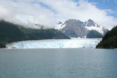
As we got closer to Stewart/Hyder, we stopped at Bear Glacier.

It was amazing the way it came right down to the lake. One thing we could not get over was all the silt the glaciers brought. We always thought that rivers and lakes fed by glaciers would be crystal clear. WRONG! The waters are grey, which makes it easy to tell if it is glacial water or not.
Once in Stewart, B.C., we ran to see Salmon Glacier, which is seen from Hyder, Alaska. So back over the border for the easiest border crossing ever!!!! NO customs! We only had to go thru customs when returning back to Canada.
The drive up to Salmon Glacier turned out to be a 20 mile drive up a mountain dirt road. I thought we were on the Top of the World Highway again!.
It was so dusty at times that we could barely see the road in front of us. But it was worth it. Our first glimpse of the glacier was the toe, pictured below.

Salmon Glacier is mammoth! It is the fifth largest glacier in North America which borders on Alaska, but is in British Columbia.
Salmon Glacier sits at 4,300 feet in a beautiful alpine valley, which descends to sea level.

It comes down a valley and splits to the left AND the right.
Stopping at the bear viewing area proved successful.
Some of our group chose to get “Hyderized,” which entails a stop at any local bar (there are only 2 and only 1 is open at a time – I think they call it time-share haha) and downing a special drink (150 proof short of Everclear.
Oh, did I mention when we went to the local grocery store in Stewart to get bread, we were told deliveries were once a week, to come back to following day….
The drive around Kluane Lake was gorgeous.
As we drove around, we could see the difference in color which is where the glacier is feeding into the lake.

The original cabin of the man who first settled in Destruction Bay.

Emerald Lake was breathtaking and they were building a house on the hill overlooking the lake.

That’s what I call a million dollar view!
We then passed the smallest dessert located in Carcross, B.C., Canada.
The fireweed is a wildflower that is kind of a predictor of the weather. Once the fireweed drops its pretty purple blooms, the winter weather will be rolling in. The blooms are dropping.,…….

Just before the U.S. Customs, it looked like we were on another planet.

It was so strange to see water ponds trapped in the rock.
The road into Skagway was something else! We descended from 3,292 feet down 11.5 miles at an 11% grade!!!

It was the first time on this trip that I could smell the brakes. IT WAS SCARY!
Our day trip over to Juneau was by water taxi.
We pulled into Juneau at low tide.

Juneau is the only capitol city in the United States that you cannot drive to. It is only accessible by water or air. There is a huge icefield that cuts off the land which they are “considering” building a road across. I don’t think that will happen in our lifetime.
While on the ferry over to Juneau, we saw plenty of wildlife, which included 3 humpback whales
Bald eagles

Harbor Seals.

bears

Alaska’s first lighthouse

As well as 2 more lighthouses
We visited the Mendenhall Glacier, which we learned is receding 40 ft. per year.
The visitor center had photos of the glacier over the years.

|
|

|
| 1909 |
|
1912 |

|
|

|
| 1920 |
|
1932 |

|
|

|
| 1953 |
|
2013 |
The visitor center has tv monitors with a slide show of the glacier over the years. We were pleasantly surprised to see a photo from 2004 with Adventure Caravans prominently displayed!

On our return trip, we ran into some fog, which because really eerie.

Thank goodness for GPS.
The next few days are drive days to basically get to Scagway, Alaska.
The scenery, as usual, was beautiful.
This was one of the muddiest rivers we’ve seen.

As we topped over a mountain, we saw a car making a uturn in the middle of the 2 lane highway. We KNEW they saw something! Sure enough.

A MOOSE!!
The road to Destruction Bay should have been called Destruction Highway.
The frost heaves really play havoc in this area.

So much for some of the people washing theirs rigs the day before.
After rocking and a rollin on that road, we FINALLY made it in to the campground. What a view!!!!
Loren, the owner, treated us to a wonderful dinner and a one man show. He was terrific! He sang, recited a poem of how he ended up in Destruction Bay, and told us stories about the area. The Kluane Lake across the street is a glacier fed lake. It froze 6 feet thick this past winter! The worst that they can remember. The ground gets so frozen in the winter that 7 months out of the year Loren does not have running water and his septic field is frozen. It averages -46 degrees. He “says” he’s not nuts, he just loves the mountains.
The drive from Palmer to Valdez had some Oh SH__T roads!

But a beautiful drive
And we saw a moose!

(it’s the little speck in the middle of the photo) Unfortunately Bill drives too fast for me to get good photos.
A few glaciers. Worthington Glacier is pictured below right.
Oh no!, and dirt road!

Over Thompson Pass, 2,678 ft. above sea level, an 8 mile descent, 8% grade.
The ship Kodiak from “The Deadliest Catch” was docked in Valdez.

While on the board tour, we saw sea lions

salmon boat

icebergs

otters basking in the sun.

seals

Meads Glacier
We stayed long enough the see the iceberg calf (break and fall off). Pictured below is a piece breaking off in the middle, bottom of the glacier (if you can see it in this small photo).

In the evening we went bear seeking, but first stopped at the fish hatchery, where we saw the salmon running.
They were so thick, that you could almost walk on them.

Since the salmon were running, we just KNEW that the bears must be around. A mama grizzly and her 4 cubs live in the area. As we drove over the bridge, THERE SHE WAS FISHING with one of her cubs.

It was easy to know that she was out there as we crossed the bridge.

Check out the cub catching his salmon.
http://youtu.be/fdftn_wbesw
Then there was the black bear back at the campground. He’s been hanging around trying to get into the garbage, so we were being real careful. The morning of our breakfast, he was sniffing around. As I was standing between 2 motorhomes, he came from under one of them. When I screamed, he took off towards Jackie. WATCH OUT JACKIE! (she’s standing by the picnic table)

I only got a quick video of him because I didn’t realize my camera was in video mode instead of picture mode.
http://youtu.be/w412irBxngk
Here he is, not far from our RV running into the wooded path back to his home.

Arriving in Palmer, we had a dessert party. S’mores and doughboys! I know everyone knows what a s’more is, but do you know what a doughboy is?

It’s a biscuit wrapped around a wooden dowel rod and cooked over the open campfire.

THEN you take the biscuit off the rod and fill it with goodies, like chocolate, pudding, cherries, whipped cream, pizza sauce, cheese, whatever your little heart desires.

There’s a lot of history in Palmer. It’s where the government chose farmers from Minnesota, Wisconsin and Michigan, between the ages of 25 and 40, with Scandinavian backgrounds to settle in this area of Alaska. For $3,000 on a 30 year loan, they received 40 acres of land (picking numbers out of a box for their tract of land) and a government built house, barn, a well, and an outbuilding. Approximately 204 families were chosen. The Matanuska Valley was selected in 1934 for this colony.
The relocation became a success for many as the depression hit Americans hard and Alaska had good agricultural potential. These families didn’t have much time to think about relocation. Some had just hours the decide and just a few days to pack up.
Transient workers from California were sent ahead to start the construction for the colony, however, coordination and supply problems delayed construction so that many facilities were not ready for these new colonists. They arrived in Palmer to find that their house was a tent! When the second group arrived, their tents weren’t ready so many had to double up!
The colonists eventually began building their own homes, against the government regulations, and were finished by Oct. 30, 1935, a feat believed impossible.

More than 60% of the colonists left within a few years….
We visited the Palmer Visitor Center and Museum. Next to the visitor center is a garden, flowers and vegetables, much like the original colonists grew.

Even though the winters are very cold, the summers are beautiful with almost 24 hours of sunlight. Check out these cabbages below.

Palmer holds the world record on cabbage at 80 lbs in 1970.
Pictured below is one of the houses constructed in 1935 and relocated in 1995 for viewing.

Two of the ladies that showed us around are descendants of the original colonists.
Outside of town we visited the Musk Ox Farm. The Musk Ox once roamed Alaska 600,000 years ago, but by 1865 they were extinct in Alaska. Canada and Greenland protected the musk ox. In 1930, Congress spent $40,000 to purchase and transport musk ox to Alaska. There is approximately 5,300 musk ox in Alaska today.
Thanks to John Teal, who domesticated musk ox, we now have beautiful knitted items from the musk ox fibers, called qiviut – one of the rarest fibers in the world, at a very dear price!
Qiviut is 8 times warmer by weight than sheep’s wool and it is SOFT. It DOES NOT shrink or felt. It dries in about10 minutes. The yarn is sold at approximately $95 per oz.
On the way back to the RV park, we stopped at Hatcher’s Pass for some photos.

Looking straight down

This is all glacier silt, which is like quicksand.
Our drive to Seward was the BEST! I got a great photo of a moose grazing alongside the road.

As I was taking one of the photos, someone’s head popped into view. It’s a good thing that moose wasn’t in a charging mood.
The views were spectacular

as was the view from our rv park.

While in Seward, we visited the Alaska Sealife Center where we learned about the sea life that we were going to experience the following day on the boat tour of Resurrection Bay.
And enjoyed an afternoon of shopping in a cute little town.

Exit Glacier, just outside of town, adds about one inch of sediment to the valley each year. That is enough gravel for building and construction in the Seward area!

Kenai Fjords glacier and wildlife cruise. What a wonderful day!
There was actually a military post above right during the war.
We saw eagles, seals, puffins, and humpback whales.
And, of course, a lot of glaciers.
The photo above, right is a glacier that has where icebergs broke off of it and are captive in Bear Lake.
Pictured below are trees that were damaged in the 1964 earthquake. All the land shifted and dropped down, the salt water came up and basically preserved the trees, so they are just standing there, dead…..

Kind of how I envisioned the petrified forest before I saw it……
Finally a free day and time to take a ride on the motorcycle! While some of the caravaners went salmon fishing, or exploring Seward, Bill and I took the bike to Whittier. It was a 190 mile round trip. Needless to say I was a bit sore when we got back. But it was worth it!
It was a BEAUTIFUL day and a BEAUTIFUL ride.
To get to Whittier, you have to go through a 2 ½ mile one lane tunnel. This tunnel is used for cars AND trains. The motorcycles go after the cars and buses. We were told because most accidents are the cars hitting the motorcycles.
THANK YOU, we didn’t mind waiting. As we were going thru the tunnel, Bill could see a dim light coming from behind. When we got out of the tunnel & parked, we found that we had a train behind us!

Whittier is a small port town where the cruise ships and ferries load and unload passengers from buses or the train.

There are glaciers all around. The one highrise building, we thought was a hotel, turned out to be the only apartments for the local workers.

So all of the locals have almost the same address and they all have a wonderful view.

Not too much to do here, but we did have a nice lunch with a great view.

There were glaciers on both sides of the mountain.
We found we had a 45 min. wait to leave back thru the tunnel. While waiting, we had a nice chat with a young woman who came to Whittier from Seattle 2 years ago.

She gave us quite an insight as to living in a small community.
The drive was full of beautiful TALL mountains with some spottings of glaciers.
One thing we saw different were the mud flats. We haven’t seen those since we were in New Brunswick, Canada.
The tide here changes about 6-8 feet and when it goes out, it exposes the silt which was basically brought by glacier.
The view of the Bay in Homer was very pretty. The fireweed is in full bloom and you can see the glaciers across the way.

Watching the moon rise over the mountains was like watching the sunrise.

As we drove around, we found a restaurant called the Blue Bus. People are so creative!

We made our way over the Anchor Point, which is the most western part of North American that you can “drive” to.
Mt. Iliamna, pictured above, right, across the water, is a 10,016 foot active volcano. The sign said it last erupted in 1953, but someone mentioned it erupted as recent as 2011. Ash covered as far as Anchorage. On a clear day, you can see from this viewpoint 5 active volcanoes, known as the “Ring of Fire.”
Drive back to the town of Homer, we took a ride up on the bluff and had a beautiful view of the Homer “Spit” and glaciers across the way.

There were some beautiful houses up there with a fantastic view. Some were for sale so does anyone want to relocate?
Leaving wet Denali proved to be somewhat of an eerie drive. The clouds covering the mountains reminded us of the Smoky Mountains, only these mountains are much larger.
Once the clouds cleared and the sun poked out, we could see the beautiful colors of the mountains.
We FINALLY got a glimpse of Denali – Mt. McKinley, as I knew it, has been renamed its Indian name of Denali. Mt. McKinley is the tallest mountain in North America reaching a little over 20,000 feet above sea level. It is difficult to get a good photo of the mountain because it is hidden in the clouds more often than not.

Very few people are ever successful in climbing this mountain, but many try. The temperatures easily reach -40 degrees and at times -70. The winds are so strong, as the jet stream flows through, that hikers have been blown off the mountain.
The captain of our rafting trip successfully climbed the Summit. It took him 26 days. Anyone can attempt to do the climb, but must not leave anything, and I mean ANYTHING, behind on the mountain. You also go up with a “team” and you must rely on your team for a safe return. The Park Service will tell you, do not rely on them for rescue.
None of my photos can compare with Teri’s. They flew up to 12,000 feet and landed on a glacier that was 8 or 9,000 feet above sea level.
We took our first ride in a float plane to view Anchorage and its surrounding area.

Taking off was a bit exciting as you saw the spray of water from the floats and then you were airborne.
Pictured below is a moose and her calf. They are the little dots in the middle of the photo.

We also visited a heritage center where we learned the local culture. There was a demonstration of dancing and the young man singing told us of his family and growing up on one of the western islands of Alaska. It’s amazing that they have no stores and their existence is dependent on each member of the village. They are allotted a number of whales they are allowed to kill by the number of people in their village.

After they danced for us, they asked the audience to dance for them. Marilyn was a real trooper.

We later had a wonderful dinner with show and a trip to the gift shop. As soon as we walked in, there was a HUGE chocolate fountain.

Our drive from Fairbanks to Denali included being in the middle of a “hand powered” cycle race. I included these photos for “T.”
We began our bus tour thru Denali National Park at 6 a.m. YES, I SAID 6 A.M.!!!
Two hours into our tour, we spotted our first grizzly!
The zoom on my camera wasn’t very good, so I took advantage of Guest Rod’s great shot of the bear.
We next spotted a mama grizzly and her two cubs. Mama is in the middle of the photo below, one of the cubs is to the right and the other is just above, barely visible because of the shrub. Of course, none of them are barely visible because of my zoom….

I got a kick out of our guests all trying to get photos

Even on our cloudy day, the view was AMAZING!!!!!!
The last big glacial advance plowed through this valley about 10,000 years ago. Denali’s wandering meltwater rivers, cloud with glacial silt and rock fragments, are evidence of ongoing glacial and mountain carving.
Pictured below is the tundra that was once had a glacier flowing through.

Pictured below is the famous spot for taking the “reflecting” photo of Delani/Mt. McKinley. There was even a photographer sitting there waiting for that perfect moment.
As luck would have it, it was too cloudy for us to witness. We later found out that this year hasn’t been a good year for viewing.
Stopping in Kantishna for lunch at the Backcountry Lodge

Another grizzly sighting.

As the day started to clear, we got some beautiful shots of the Alaska Mountain Range.

Before leaving the park, we got some photos of a huge moose, picture below IF you can see him (he’s smack in the middle of the photo)

Some of our group went white water rafting. There was a 2 hr. and a 4 hr. tour. Bill and I took the 4 hr. tour and chose to have “Captain Kevin” row us down instead of paddling ourselves. I’m glad we chose not to paddle. We were in the back of the boat and hardly got wet. Since it was about 53 degrees with little sun and the water was glacial water, which had only melted within 24 hours, it was nice not getting soaked, which is more than I can say for the poor people in the front of our boat!
This was the first time . we’ve ever been in glacial waters. It’s like a grey, cloudy color and is about 36 degrees. YIKES!
Below are some of the waters we navigated through.
Mt. McKinley, as I knew it as, has been renamed Denali. Mt. McKinley is the tallest mountain in North America reaching a little over 20,000 feet. Very few people are ever successful in climbing this mountain, but many try. The temperatures easily reach -40 degrees and at times -70. The winds are so strong, as the jet stream flows through, that hikers have been blown off the mountain. The captain of our rafting trip successfully climbed the Summit. It took him 26 days. Anyone can attempt to do the climb, but must not leave anything, and I mean ANYTHING, behind on the mountain. You also go up with a “team” and you must rely on your team for a safe return. The Park Service will tell you, do not rely on them for rescue.
Finally on our way to the Big City.
The drive brought us to the end of the Alcan Highway.

At the end of the Alcan Highway is a roadhouse. There I saw a photo of Dawson City when it was first settled. Notice the mountain in the background is unchanged today with the slide, or erosion.

The drive was same as usual – Mountains, skinny black spruces that are very old (but don’t look it),
Although poking thru those trees was a glimpse of the Alaskan Mountain Range.
The rivers are different from back home, filling with silt brought by the glaciers. Since the silt is constantly moving, it would be difficult to navigate these waters by boat.
At yet another roadhouse, we found someone working on his Diamond Willow Walking Stick, a favorite up here in Alaska.

Our first glimpse of the Alaska Pipeline. I’ve heard so much about it for so many years, it was exciting to finally “see” it.

Then our trip got very exciting as we saw a moose, alive and well!
Stopping at the “knotty shop” we picked up some of our own “raw” diamond willow branches to make into walking sticks.

Last stop before the campground was the North Pole. Complete with Santa!
When we unhooked our car, we lifted the hood & we could not believe all the dust still on the engine from Top of the World Highway!

We took a great Riverboat tour down the Chena River. We stopped at the Susan Butcher Sled Dog Center. The dogs pulled the 4 wheeler, approximately 800 lbs. around the property. While the trainer was hooking them up to the leads, they were going crazy wanting to get started.
Susan was the first woman to win the Iditarod Trail Sled Dog Race in 1986. She went on to win the Iditarod in 1987, 1988 and 1990. She died in 2006 from complications of a bone marrow transplant. Her husband and two daughters are now running the center.
We saw a float plane take off and land.
We visited the Athabascan Village and learned a lot about their heritage.
Then we got to meet the mush dogs up close.

We visited the University of Alaska Museum where we learned about the dinosaur age

The woolly mammoth hide pictured below was discovered in 1948 at a gold mine located in Fairbanks Creek. This is the best preserved mammoth to be found in North America.

and the indian heritage
Speaking of gold mining, there were also gold nuggets and dust on display.

As we walked over to the ice museum, we saw a portable jail driving down the street. The next thing we know, we were informed there was a warrant out for our arrest and we were jailed!

In order to get out of jail, you can to do the “can-can” with the girls.

Our wagonmaster, Ken, was also arrested. He REALLY got into dancing with the girls.

The ice museum was amazing! The ice sculptures are kept at 20 degree F temperatures in their building and brought out to the park in the winter for the ice sculpting festival.

The demonstration of ice sculpting was pretty cool (in more ways than one)

Our visit to Dredge #8

proved to be profitable to some of our guests. Bill and I got a whole $18 worth of gold dust.
Our Salman Bake showed me the way! I now have a stock of Sockeye Salmon in my freezer!
Because our group missed Banff and Lake Louise, we were able to take them to Chena Hot Springs in its place. Some enjoyed the healing waters of the hot springs.

It turned out to be our best trip yet for moose sightings. One on property and a few on the bus ride home.
We visited the ice house and saw some beautiful ice sculptures
If you choose, you can have an appletini from an ice glass!
We toured the geothermal power plant and their green house where plants are grown hydrophonically.
Fairbanks was my first opportunity to get a photo of and “almost” sunrise.

Since the sun never seems to go all the way down, it’s a little difficult.
Sad to leave Dawson City and its wonderful hospitality. It’s hard to believe that people actually live up here in the winter.
Leaving Dawson City was an “adventure” in itself. We began to line up for the ferry crossing at 8 a.m.

Bill and I, being the tailgunners and last in line, did not get across the 20 min. ferry ride over the Yukon River until 2:40 pm.!!!!

Most of our group sat for hours and hours waiting while they loaded the ferry with “locals”, worktrucks, tour buses and small class c rvs. We were lucky to get one rv at a time on the ferry. A few times they took more than 1. Oh, and then they had a “safety check”, got the ferry stuck in the mud because they loaded a fuel tanker improperly….. THEN, they had to fuel the ferry and did a shift change!

Once we got “close” I jumped in the truck so I could load with our RV. They loaded our RV & our “twin”
One across, we had to prepare our tow vehicle for the “Top of the World Highway” gravel road.
It made for a VERY long day.
So now that we’re exhausted from “waiting” we begin our “adventure” of driving over the “Top of the World” highway. The beginning didn’t seem bad. It was a climb to get up to the top of the mountain.
If you can see a little white dot on the photo above, right, that is one of our guests climbing the mountain.
It wasn’t long before we hit gravel road
The road just kept going and going and going
110 miles of dirt and gravel with some patches of pavement.
The views were amazing!
There are remnants of snow still in some areas.

Drive the highway would be a lot better if it weren’t for the cars, buses, and trucks flying by….

Crossing the border into Alaska was an easy crossing, although they confiscated the firewood we were carrying for the caravan, which we knew we should not have brought, but our wagonmaster just about guaranteed that they would not ask if we had firewood…….

You just never know what questions they will ask. This was probably the first time they did not ask us how much liquor we had. This crossing was pretty unique as it is one building with US Customs on one side, and Canadian Customs on the opposite side. We understand that it used to be run by a husband and wife.
2520 MILES LATER
The drive to Dawson City was relatively boring compared to other days. I think the only animal I saw was a rabbit. But it was a pretty drive.

The highlight was stopping for the granddaddy of cinnamon buns. They were as big as a dinner plate as you can see below.

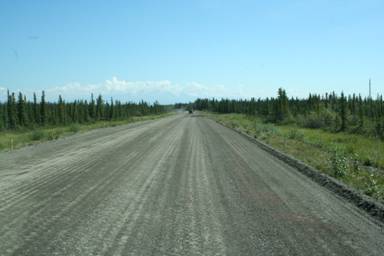
Today we got a taste of dirt/gravel roads.
We reached the Tintina Trench, a place where there was visible proof of the earth’s plate movement.

Less than 200 million years ago, this area was covered with tidal flats and river deltas at the edge of an inland sea. It is now called the Whitehorse Trough. The river sediments were buried, compressed and turned to rock. The area was lifted when the plate holding the oceanic floor, inland sea and islands connected with the crumpled western edge of North America.
Until 3 million years ago, rivers draining this area flowed southward to the Gulf of Alaska. During the ice age, expanding glaciers in the coastal mountains plugged the passage downstream, causing the river to back up. Now the relatively young Yukon River flows northwest to the Bering Sea.
The five Finger islands and riverbank are composed of pebbles and boulders embedded in a sand and mud mixture. It is more resistant to erosion than surrounding mudstone layers.

As we got closer to Dawson City, it looked like maybe the bridge was washed out prior to our arrival. Thank goodness they had time to work on it.

Just outside of the town limits, we saw the remnants of the dredging that went on during the “Klondike Gold Rush.”

It was amazing that they just built housing developments on top and around these rocks.
I love the “signs” announcing the town of Dawson City.

Dawson City took us back in time to the early 1900s.

The roads are still dirt, the buildings are being restored. Below is the original bank building that the city just bought and will be restoring.

We had a wonderful guide to walk us through town and tell us some history. She gave us many examples of why the lifestyle in Dawson City is unconventionally different.

She herself lives across the river, which you get there only by ferry and over the “ice bridge” in the winter, in a house with no “grid” electric or water. They buy their water in town in large containers and run generators in the winter & use solar in the summer. Solar works great up here in the summer since it is only dark a few hours each day.
Our guide told us of a friend she met when she moved to Dawson City in 1996. At that time they lived across the river in a tent, a place they called “tent city.” His name is Bill and he now lives in a cave. No one knows his last name. He’s known as Caveman Bill. Can you imagine living in Dawson City in the wintertime, where it gets below 0, in a cave?! A “local” told me that it can get as cold at -50. With cold days like that, it makes it easier to accept the -30. Yikes!
The buildings below show you what permafrost will do to a building.

In the photo below, you can see where the mountain behind the town slide over 10,000 years ago.

The original post office building.

Then we trekked up the mountain to “Midnight Dome.” This is where you go to see the very quick sunrise or sunset. We didn’t see either, but what a spectacular view of the area!
You can see where the mining was going on in the photo below, left. Below right, you can see the “Top of the World Highway” which we’ll be taking.
If you look closely above right, you can see a little white spec in the middle of the photo. That is a fifth-wheel driving up the Top of the World Highway.
On our free day, we visited the “Dredge #4.”

It is not cost effective to use this system anymore. They are basically strip mining now.

But there are some areas where you can “pan for gold” yourself.

They did manage to leave the first “cabin” built during the Klondike Gold Rush, pictured below.

The show at Diamond Tooth Gerties was entertaining.
This is a town that lives in the light in the summer and lives in the dark in the winter. The sun does not rise in the east and set in the west daily. In the summer the sun is up and seems to go around at one point it dips down below the mountains for a few hours and comes right back up. In the winter, the sun is below the mountains and at one point it comes up for a few hours during the middle of the day and back down again. This time of the year, the sun sets about 12:30 a.m. and is up before 4 a.m. Below left is a photo I took at 11 pm and the photo below right was taken at 3:30 a.m.
Above right photo was taken without a flash and was the darkest it’s been in Dawson City!
Dawson city is the perfect place to see the Northern lights, but we’d have to come up here in the winter. They say the lights are there in the summer, but you just can’t see them because it’s not dark. A “local” told me the best time to see the Northern Lights is in March/April.
The road just seems to go on and on.
Until once again we come to the snow covered mountains.

Seems the people coming down the incline ahead must be in a hurry. Over on the right side of the road were pieces-parts of a trailer scattered all over. You know what they say, “haste makes waste!”
Once in Whitehorse, we passed the airport and saw the world’s largest weathervane.

The airplane pictured above shifts with the wind!
Within the town, we toured the S.S. Klondike, the largest sternwheeler on the upper Yukon River. Built in 1929 as an ore hauler and rebuilt after she sank in 1936, she carried passengers and cargo until 1955. Among some of the things she hauled was Borden’s “Reindeer” milk. She was the last Yukon River sternwheeler in active service.

As I yelled from the top deck, Jackie offered to catch me.

We were entertained in the evening at the “Frantic Follies,” a great vaudeville show.
Above right, they are playing “saws.” They put on a great show, which included choosing a member of our group, Ralph.
I think he was loving every minute of it.
Our drives are becoming more memorable each day. Today we saw 4 black bears at separate times.

We were able to get the attention of the one pictured below while he was eating on the side of the road. I think we annoyed him so much that he decided to go to the other side of the road.
We also saw A LOT of bison along the road.
This bison in particular was the king of the daddies and look at that evil eye he was giving me.

Then there was construction again…
Once we all arrived to Watson Lake, we went over to the “sign post forest” to place our Adventure Caravan sign.
A few of our guests made their own sign and found a place to attach them.
Pictured below was Ralph and Robin. Ralph was a shop teacher and helped a lot of the guests make their signs.

While walking through the “forest” we found our good friend Maddie & Spence’s sign, placed in 2012, which lists all the years they were there!

The first sign was placed by an Alaska Highway construction worker in 1942.
Today there are over 75,000 signs from all over the world. We even found one from our local area. Read below what he had to say.

After our wonderful 4th of July dinner, which included Buffalo Hot Dogs, provided by Ralph and Robin, we played bingo.
Laird is known for their outdoor hot springs. It was a beautiful drive to get there.
I think the prettiest overlook of the day was the one pictured below.

We stopped for cinnamon buns and who would have thought that the best ever would have come from an RV campground which is pictured below.

It’s called Testa River RV Park and it’s in the middle of nowhere. We had to wait 45 min. for the buns to come out of the oven, which wasn’t bad since some of our guests were told the wait was 1 ½ hours. They make 50 in a batch and they were on their 4th or 5th batch when we got there. We were told someone ahead of us bought a couple of dozen and had them shipped to Australia!
Below left they are ready to be popped into the oven and on the right they have just popped out of the oven.
The owner is also the baker. Pictured below he is adding the finishing touch of the icing.

They were the biggest and BEST cinnamon buns I’ve ever had. They were just as good the next day.
The only wildlife we saw today was elk.

Before arriving at Laird Hot Springs, we went over, or thru, Stone Mountain.
By the time we got to Laird Hot Springs, we were too tired to think about going to the hot springs, not to mention the mosquitos were super bad. I did get photos from a guest.

We camped at the Provencial Park, which meant no hookups and not running the generator all night. What a wonderful quiet and peaceful night.